


Les Signaraux - L'Arboretum

maupassant38
User
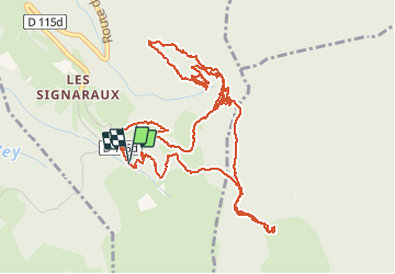

Length
7.6 km

Max alt
1426 m

Uphill gradient
217 m
Km-Effort
10.6 km

Min alt
1278 m

Downhill gradient
223 m
Boucle
Yes
Creation date :
2020-09-04 09:27:06.988
Updated on :
2020-09-06 15:59:24.463
1h53
Difficulty : Easy

FREE GPS app for hiking
 SityTrail
IGN / Geographical institutes
SityTrail Plus
The world is yours!
About
Trail Walking of 7.6 km to be discovered at Auvergne-Rhône-Alpes, Isère, La Motte-d'Aveillans. This trail is proposed by maupassant38.
Positioning
Country:
France
Region :
Auvergne-Rhône-Alpes
Department/Province :
Isère
Municipality :
La Motte-d'Aveillans
Location:
Unknown
Start:(Dec)
Start:(UTM)
716058 ; 4979332 (31T) N.
Comments